Explosive eruption at Kilauea Summit — May 17 2018
An explosive eruption at the Kilauea summit occurred near dawn local time on May 17, 2018 according to the USGS Hawaiian Volcano Observatory. The Washington Volcanic Ash Advisory Center indicates that the eruption reached 30,000 feet. Meteorological remote sensing tools like satellites and weather radars can provide complimentary information about clouds produced by explosive volcanic eruptions.
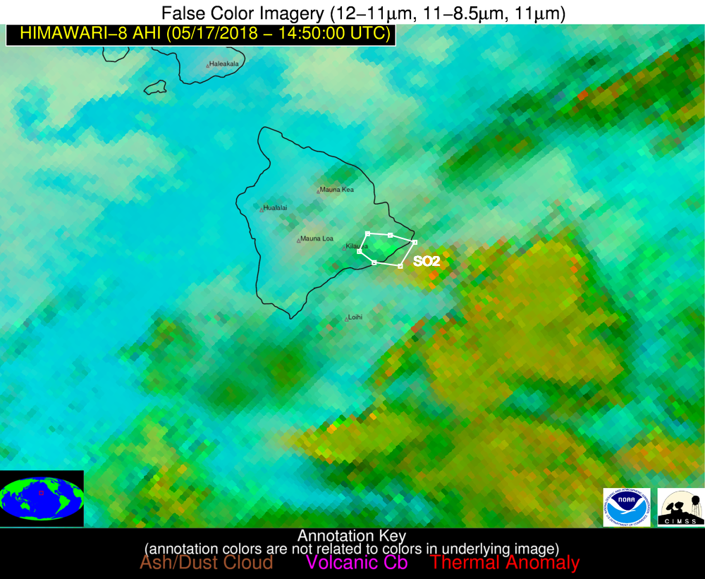
Below is an annotated image and a short animation of Himawari-8 ash/dust/SO2 false color imagery between 1400 and 1510 UTC 17 May 2018. At 1420 UTC an SO2 plume (indicated by the green-ish colors; more information on ash/dust/SO2 false color imagery can be found here) located east of the Kilauea summit emerges and is subsequently advected to the east by the end of the loop. While an ash signature is not evident in the RGB imagery currently, one must not make the conclusion ash is not present, as complex underlying conditions, including meteorological clouds can mask the ash signature. Other factors include, but are not limited to, ash grain size effects and dry and wet deposition. Other sources of information, such as cameras and radar clearly indicated that ash was present (see below).
Using the 12 UTC 17 May 2018 observed sounding from Hilo, Hawaii (below), one can use the easterly motion of the SO2 to deduce a plausible height of the SO2. Assessing the wind profile from Hilo, a large depth of the middle troposphere exhibited 10-15 knot westerly winds (ranging from roughly 16,000 feet to 32,000 feet AGL). This would suggest the SO2 moving to the east, away from the summit, must reside somewhere in that broad layer. Because there is a lack of wind shear within this layer (changing wind speed and/or direction with height) the wind analysis only provides a large layer in which the SO2 likely resides in this case.

Combining the satellite and radiosonde height analysis with National Weather Service radar data, one can more accurately pinpoint the height of eruptive column because radar energy is reflected from volcanic ash particles and hydrometeors (if present) back to the radar. Below is an animation of the NWS South Shore, Hawaii radar elevation angles (1413 – 1420 UTC 17 May 2018). The various tilts show moderate to strong radar reflectivity associated with eruptive column to near 20,000 feet and faint echoes exist as high as the 10.0 degree elevation scan (over 27,000 feet). The radar analysis suggests the cloud likely reached 30,000 feet, which is in excellent agreement with the Washington VAAC assessment as well as the possible height range inferred from the above satellite/radiosonde analysis.
Update
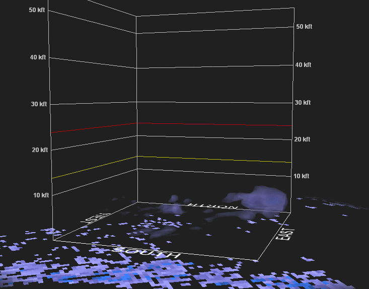
To gain additional insight into the eruption, a 3D radar animation from 1357 UTC to 1507 UTC is shown below. The radar indicates that after achieving a maximum injection height of about 30,000 ft, the particulate cloud, as sensed by the radar, quickly decreases in height. The decrease in height may be caused, in part, by the preferential sensitivity of the radar to larger particles. However, the rapid decrease is consistent with a lack of ash signature in satellite data. A more detailed analysis is needed in order to draw firm conclusions.