JPSS Volcanic Hazards Initiative: Introduction to the VOLCAT SO2 Product Suite
The NOAA Joint Polar Satellite System (JPSS) Volcanic Hazards Initiative is aimed at developing products that address current and future needs of the International Civil Aviation Organization (ICAO) International Airways Volcano Watch (IAVW), including products that support volcano observatory operations. The ICAO/IAVW sets the standards for volcanic ash advisories issued in support of aviation (NOAA is one of the agencies responsible for volcanic ash advisory issuance). In response to the emerging needs of aviation stakeholders, ICAO is leading an effort to develop volcanic sulphur dioxide (SO2) information services. JPSS Volcanic Hazards Initiative team, which consists of top experts from the research and operational communities, are involved in this process through the World Meteorological Organization Volcanic Ash Advisory Center (VAAC) Best Practices initiative and the Volcanic Ash Science Advisory Group (VASAG). The emerging ICAO/IAVW requirements for SO2 provide compelling motivation for developing SO2 products and services that take full advantage of remote sensing data, including JPSS measurements. Given our remote sensing expertise and comprehensive understanding of the emerging operational needs the JPSS Volcanic Hazards Initiative team is well qualified to support the development of SO2 information services. This post will introduce some new multi-sensor JPSS-based SO2 products that were developed in support of the ICAO/IAVW. All of the products are part of the NOAA/UW-CIMSS VOLcanic Cloud Analysis Toolkit (VOLCAT). VOLCAT consists of a series of products and services derived from multiple satellites and other data sources using artificial intelligence and other techniques.
The JPSS Program satellites, which includes S-NPP and NOAA-20, carry three instruments that are sensitive to SO2: VIIRS, CrIS, and OMPS. Our current work is focused on extracting maximum value from VIIRS and CrIS in a synergistic manner, since, unlike the ultra-violet based OMPS, sunlight is not required to utilize VIIRS and CrIS for SO2 applications. However, when sufficient sunlight is present, OMPS is extremely sensitive to SO2 and will be the focus of future VOLCAT algorithm development work. CrIS is a hyperspectral infrared sounding instrument. Hyperspectral infrared sounders are very sensitive to certain trace gases, including SO2. VIIRS, which is an imaging instrument, is far less sensitive to SO2, but it does provide important visual context that complements the quantitative information derived from CrIS. Within VOLCAT, a sophisticated algorithm is applied to CrIS data to detect SO2 when present in excess of background concentrations (away from where significant natural and anthropogenic sources are located). Probabilistic height and loading information is also derived for each CrIS field-of-view with above background SO2. The CrIS SO2 products are subsequently refined using VIIRS and serve as the basis for triggering VOLCAT SO2 alerts when certain criteria are met. We will now introduce a subset of the VOLCAT SO2 product suite using examples generated in near real-time.
The most effective way to introduce the SO2 products is through the automatically generated VOLCAT SO2 alert reports. The SO2 alert reports are analogous to the VOLCAT thermal anomaly, volcanic ash, and volcanic Cb alert reports that subscribed users have become accustomed to over the last 5+ years. The URL found in the alert email and SMS messages will direct users to the SO2 alert report on the VOLCAT website. A screen capture of an actual SO2 alert report is shown below.
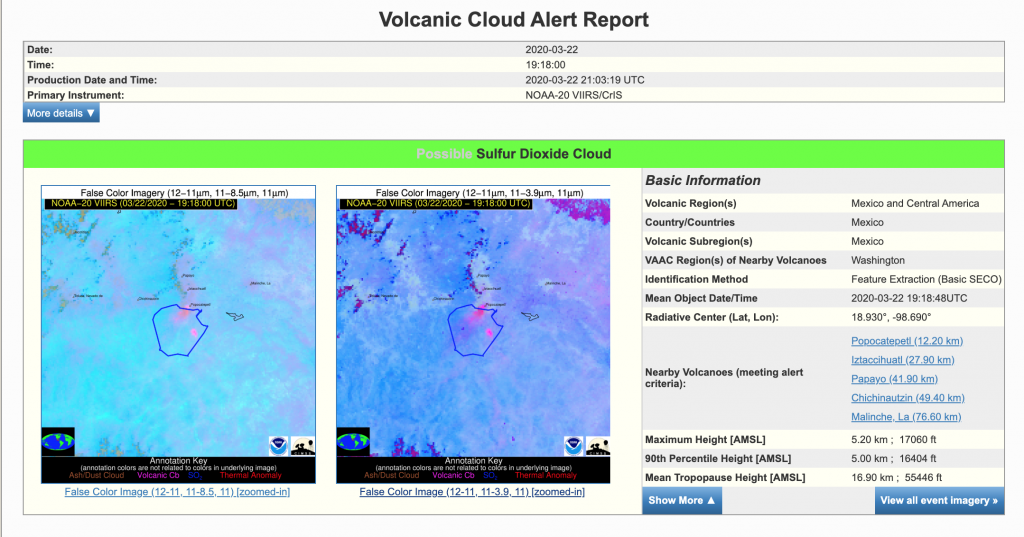
First note that the typical latency (see difference between time of observation and production time in alert report header) of JPSS derived alerts is 2-3 hours due to data access limitations. The inset false color images from VIIRS, along with the geographic information to the right of the images, allows users to quickly assess is further action is required. The blue polygon overlaid on the false color images represents the region where the VOLCAT algorithms detected SO2. An estimate of the maximum and 90th percentile SO2 cloud/plume height is also listed to the right of the images. In general, the smaller the difference between the maximum and 90th percentile height, the greater the confidence in the maximum height. Users can view larger versions of the images and additional image types by clicking on any of the inset images in the alert report.
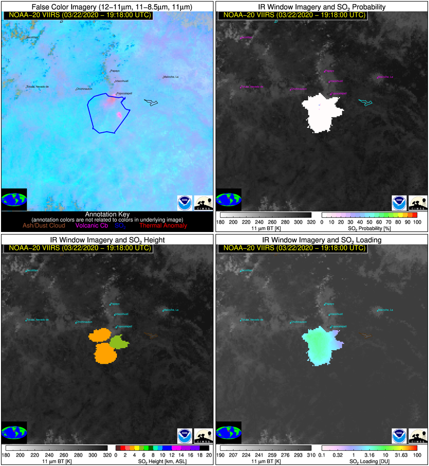
The most essential images, available in SO2 reports, are the ash/SO2 VIIRS false color image (upper left in four panel image shown above), VIIRS SO2 probability (upper right), SO2 height (lower left), and SO2 loading (lower right). The ash/SO2 false color (or RGB) image is constructed from spectral channels centered near 8.5, 11, and 12 um. If SO2 is present in large quantities, it will appear green when little or no ash is present and yellow when detectable ash is present. In the absence of VIIRS detectable SO2, volcanic ash will appear pink/red. CrIS is far more sensitive to volcanic ash than VIIRS, so the SO2 feature depicted in the alerts will not always be visible in VIIRS imagery. One way to assess the VIIRS SO2 sensitivity, in a given scene, is the VIIRS SO2 probability image (upper right). In this example, from Popocatepetl (Mexico), the VIIRS-derived SO2 probability is very small, which is consistent with the lack of an SO2 signal in the VIIRS ash/SO2 false color image. The SO2 height and loading are largely driven by CrIS and are generally accurate even when an SO2 signal is absent in VIIRS imagery. The SO2 height will appear patch-like because the CrIS results are simply sampled to the VIIRS swath, since interpolation of feature height can result in unphysical values. The SO2 loading is a measure of the total SO2 mass in the vertical column (given in Dobson Units). As such, it can be safely interpolated to the VIIRS swath, which is why it appears smoother and more spatially continuous than the SO2 height. With respect to 2020 version of the IAVW, SO2 height is most pertinent to Volcanic Ash Advisories (VAAs), as the sensitivity to SO2 height is generally greater than the sensitivity to ash height. Thus, when ash and SO2 spatially overlap (as they do in this Popocatepetl case), the SO2 height from CrIS is valuable for determining the height used in VAAs.